Soils in
Eastern San Joaquin County range from sandy loam to clay, with
wide areas of the region influenced by centuries of flood plain
run-off. Soil studies in the region reveal that the flood plain
deposits vary in thickness and density, changing from one soil
type to another within a matter of feet. The Farmington Groundwater
Recharge Program (Program) is designed to take advantage of these
unique characteristics to produce the most cost-effective, cost-efficient
and site-friendly method for recharge.
General
Description:
The
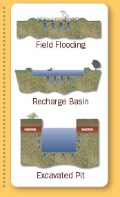
Program seeks to enroll parcels ranging from 20 to 100 acres and
construct field-flooding recharge facilities. A slope of no more
than three degrees is typically optimal, allowing varied water
depths from zero to 18 inches. A slight slope is beneficial as
it provides a variety of water depths for various waterfowl species.
Vegetation in the recharge basin may either be stubble from the
prior years crop, natural vegetation or a combination. Fields
without vegetation will change as water is applied and recharged.
Monitoring wells would be installed to track changes in groundwater
elevation and groundwater quality in response to percolation of
surface water into the groundwater aquifer.
 Construction: Construction:
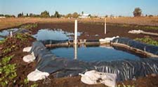
Under
terms of the property agreement with the landowner, construction
of field-flooding recharge facilities would be managed by Stockton
East Water District or the U.S. Army Corps of Engineers. Short
dirt levees may be installed in the recharge basin for erosion
control. Dirt levees would be pushed up around the perimeter of
the recharge basin. Some levees may be covered with plastic to
control wind erosion.
Operation:
Surface
water would be delivered to the parcels during the winter months,
usually beginning with the first flood flows to the watersheds.
These waters will be drawn from Calaveras, Mokelumne, Littlejohns
and Stanislaus watersheds. Depending on the sites location to
the water source, the final delivery may be via open ditch or
pipeline. Supervision of the flow of the water is provided by
the Program consultants.
Maintenance:
Maintenance
during field flooding would be similar to typical irrigation practices
for crops. This includes monitoring for levee breaks, erosion
control and other factors specific to the facility. Dry season
maintenance will be site specific and could include levee and
erosion control maintenance and tilling.
 Monitoring: Monitoring:
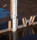
Monitoring
wells will be positioned at each site and managed by the Program
sponsor. These wells will monitor changes in groundwater elevation
and groundwater quality in response to recharge. These wells will
also be useful in determining the direction of groundwater movement.
Recharge facilities that show a consistent lateral migration of
water and therefore present a likelihood to damage nearby crops
will be removed from the Program.
|